
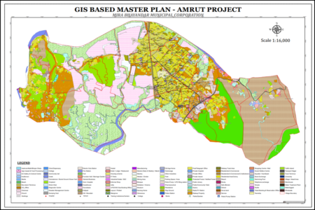
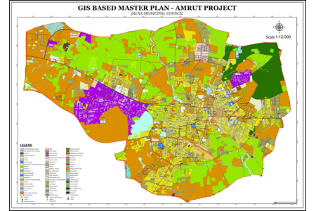
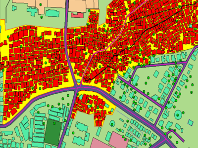
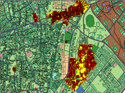
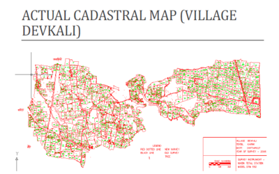
As part of flagship AMRUT project, the Ministry of Housing and Urban Affairs (MoHUA), Government of India has mandated the preparation of GIS based master plan for 44 cities in Maharashtra State. Accordingly, fund was sanctioned to Urban Development Department, Government of Maharashtra for preparation of GIS Based Master Plan for 44 AMRUT Cities in Maharashtra. However, major chunk was available for GIS database creation and rest of the fund was planned to be utilized for Master Plan Preparation and Capacity Building in Maharashtra State. Accordingly, pilot project at Wardha Municipal Council was started as per AMRUT Standards and demonstrated the same to Directorate of Municipal Administration(DMA), State Town Planning Department , and Central Town & Country Planning Organization, New Delhi. Maharashtra Urban Development Mission Directorate (MUDMD-Mumbai) principally agreed to provide funding for Basemap Preparation. Existing Urban Land use/Land cover, base map and utilities network data at 1: 4000 scale and ULB local data in GIS format are the important inputs for formulation of GIS based Master Plan and Infrastructure Development Plan. AMRUT GIS Basemap comprised of 69 classes and 475 sub classes including utilities & planning boundaries which need to be provided by respective ULBs.
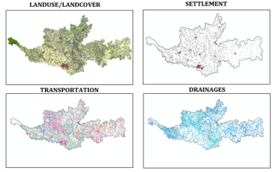
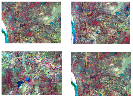
The project was initiated by National Remote Sensing Centre (NRSC), ISRO, Government of India. Realizing the potential and capability of space technology for providing cost and time-effective resource database, the Planning Commission, Ministry of Panchayati Raj and Ministry of Rural Development has proposed to prepare District Resource Atlases using remote sensing and GIS techniques to strengthen various aspects of decentralized district level planning through a coordinated approach. In view of the same, responsibility was entrusted for extending the objectives to the State of Maharashtra. The objective of SISDP project was Ortho-rectified satellite images generation for accurate depiction of earth indicators required at various planning levels, Landuse/Landcover maps creation at 1:10,000 large scale for numerous applications, Transport network maps creation for better road network planning and route management, Preparation of settlement layer along with demographic details for better analysis and distribution of government schemes.
National Remote Sensing Centre (NRSC-ISRO) has undertaken a project entitled "Empowering Panchayati Raj Institutions Spatially (EPRIS)’ with the goal to empower Panchayati Raj Institutions for resource-based and integrated spatial developmental planning in a user-friendly enabling environment. ‘Panchayati Raj Institutions (PRIs)’ refers to the participatory local self-government bodies at the three tiers of Panchayati Raj with a vision of attaining administrative decentralization. ‘Resource-based developmental planning’ refers to the planning initiating at the Gram Panchayat level that considers information about resources as the knowledge base. 'Outreach activities’ refers to (i) capacity building of Elected Panchayat Representatives, their support functionaries and facilitators; (ii) asset mapping task; and (iii) activity planning task.
National Remote Sensing Centre (NRSC) has undertaken a project entitled “Space based Information Support for Decentralized Planning–Update (SISDP-Update).” The project aims at generation of value-added geospatial products and services to meet the Gram Panchayat Development Planning (GPDP) requirements by using latest high-resolution satellite data and updated thematic database through user friendly WebGIS portal along with vigorous capacity building activities. Further, as per the scope of the overall project, state-wise mosaics of the database have to be prepared and Workshops will be organized at National/Regional/State level for awareness, training with hands on experience on mapping, development of software modules and utilization of project deliverable for gram panchayat developmental planning.

Rajiv Awas Yojana (RAY) for the slum dwellers and the urban poor envisages a ‘Slum-free India’ through encouraging States/Union Territories to tackle the problem of slums in a definitive manner. It calls for a multi-pronged approach focusing on; (1) Bringing existing slums within the formal system and enabling them to avail of the same level of basic amenities as the rest of the town. (2) Redressing the failures of the formal system that lie behind the creation of slums. (3) Tackling the shortages of urban land and housing that keep shelter out of reach of the urban poor and force them to resort to extra-legal solutions in a bid to retain their sources of livelihood and employment.
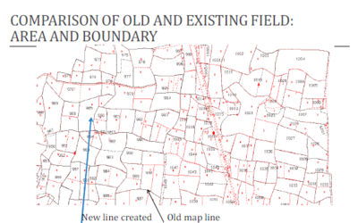
The National Land Records Modernization Programme is a holistic and integrated approach to land and property management; it provides a base for accurate data collection and core GIS related activities; it is both transparent and confidential namely transparent in the funcitoning of the Government and confidential for the citizen property data; reduces unnecessary litigation and land disputes; all property records are kept up-to-date and as the changes in the Record of Rights(ROR) is instantaneous, based on the non-encumbrance certificate of the registration department, fraudulent sale of a property is no longer possible.
Implementation of NLRMP requires use of modern and latest state of art technologies. The technologies require the staff working on the project to be trained on them so that the operational and strategic control of the data and services stays with the Government and the staff are able to operate and provide services to the user.