
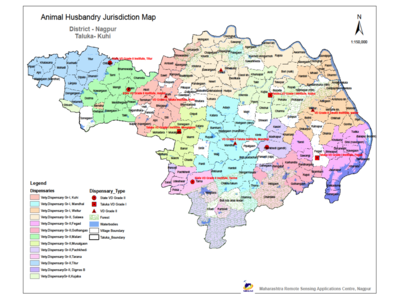
Pilot project was done for Animal Husbandry Department, Government of Maharashtra. It aims upon Strengthening department through GIS based decision-making system by analysis, easy information retrieval. Availability of timely, accurate, complete, updated information on fingertips. Finally, system so designed will help to maintain, manage, plan and analyze geographically referenced data on Animal Husbandry Resources. Methodology includes Integration of MIS with GIS database by devising unique key methodology on Village Census code 2001 or Centre Code. Database conversion of existing departmental hard/soft copies into georeferenced database (Milky Routes, etc.) and incorporating the same into GIS system. Generating GIS database layers highlighting suitable fodder sites depending upon predefined constraints of Animal Husbandary Dept.Designing GIS Modules for Data Entry, Data Query, Data Report and Data Analysis. Implement WebGIS system for on line updations of KFA attribute information, which highlight centre progress status on fingertips.Implement WebGIS system for Developmental Planning activities of AH department and finally Update GIS Database monthly as per requirement of User Department.

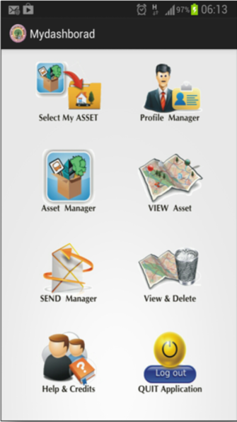

GIS oriented activities that envisage under Integrated District Planning Process includes natural resources mapping, social mapping, basic infrastructure mapping, amenities/facilities mapping, etc. The utmost important phase of asset mapping is the prime purpose of developing mobile applications i.e. SAMMS. It will enable gram panchayats to map and view their all assets (government or private) for better understanding of its strengths and weaknesses. Finally, GIS maps integrated with socio-economic surveyed information enable us to devise integrated gram panchayat development plan. The gram panchayat profile so generated would be the significant input for “Sansad Adarsha Gram Yojana”, which is ambitious move by Government of India. The objectives includes; (1) Asset mapping at Grampanchayat level using SAMS (2) Asset monitoring & analysis through web application (3) Provide the asset maps overlaid on GIS themes as required (4) Integration of MIS collected on ground with SAMMS dashboard.
GIS oriented activities that envisage under Integrated District Planning Process includes natural resources mapping, social mapping, basic infrastructure mapping, amenities/facilities mapping, etc. The utmost important phase of asset mapping is the prime purpose of developing mobile applications i.e. SAMMS. It will enable gram panchayats to map and view their all assets (government or private) for better understanding of its strengths and weaknesses. Finally, GIS maps integrated with socio-economic surveyed information enable us to devise integrated gram panchayat development plan. The gram panchayat profile so generated would be the significant input for “Sansad Adarsha Gram Yojana”, which is ambitious move by Government of India. The objectives includes; (1) Asset mapping at Grampanchayat level using SAMS (2) Asset monitoring & analysis through web application (3) Provide the asset maps overlaid on GIS themes as required (4) Integration of MIS collected on ground with SAMMS dashboard.
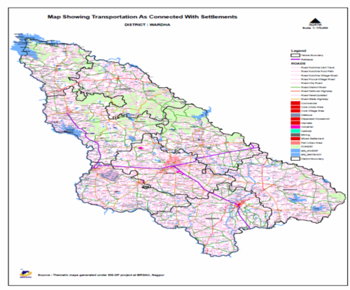
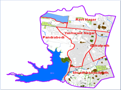
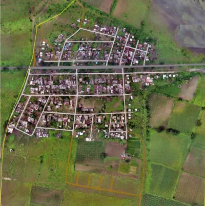
The Government of Maharashtra, Planning Department has resolved to make GIS an integral Part of planning Process and Wardha district has initiated to implement “GIS Based Decision Support System for Wardha District” as pilot project under the Innovative Schemes of the District Planning Committee Funds as a district level innovation. As a part of initiatives towards implementing E-Governance in the Wardha District and has been entrusted to carry out Geo-Spatial based application to introduce graphical interface through use of Geo-referenced maps of Wardha District. This has the objective to planning and monitoring the District for any development work and environmental aspect too.
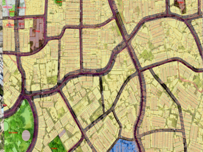
As part of flagship AMRUT project, the Ministry of Housing and Urban Affairs (moHUA), Government of India has mandated the preparation of GIS based master plan for 44 cities in Maharashtra State. However, almost every Urban Local Bodies have their own ground realities and issues thereof. In order to address technical problems of Urban Local Bodies in Maharashtra, MRSAC is the nodal agency with regards to generation and utilization of GIS database. Existing Urban Land use/Land cover, base map and utilities network data at 1: 4000 scale and ULB local data in GIS format are the important inputs for formulation of GIS based Planning and Infrastructure Development Planning as well.
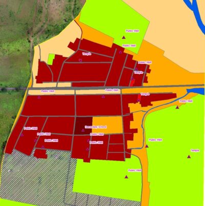
The project by Social Welfare Department of Maharashtra for GIS Based Infrastructure Mapping, Monitoring and Management System for the rural areas of the Maharashtra state. The main objective of the project is to generate GIS mapping of the basic infrastructure attributes for specific habitation/settlement which will provide a visual data, and that data visualization is presented in maps and web application. This project will also visualize and analyze the assets, infrastructures, demographic information of habitation/settlement. It includes web geo-portal for report generation and capacity building of the users for field survey and use of applications developed by MRSAC. The department intends to use android mobile based applications for mapping Existing Situation Assessment and planned activities through handholding and capacity building of village level functionaries on mission mode. It includes monitoring of government development work. The infrastructure will be mapped and visualized on the GIS domain through ‘Social Welfare’ application and web-geoportal. The indigenously developed web enabled monitoring system will prove to be milestone towards good governance for Maharashtra State in the renewable sector of energy.